 HOME
HOME JAPANESE
Noto Quake Liquefaction Hampering Land Boundary Redrawing
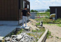
Kanazawa, June 2 (Jiji Press)--Soil liquefaction caused by a massive earthquake that struck the Noto Peninsula in central Japan on Jan. 1, 2024, has complicated local efforts to redraw land boundaries in some disaster-hit areas.
Both the town of Uchinada and the neighboring city of Kahoku in Ishikawa Prefecture were hit by a widespread lateral flow, in which the ground shifts sideways, when the 7.6-magnitude quake caused soil to behave like liquid in the phenomenon called liquefaction.
While the local governments hope to set the postquake boundaries based on the land situation after the liquefaction, the central government holds on to its legal interpretation that existing lines drawn under the parcel boundary system, which establishes boundaries based on real estate registration documents, should not be altered.
Liquefaction during the Noto quake caused a lateral flow of up to 3 meters along a prefectural road running north to south through Uchinada and Kahoku.
A 44-year-old resident of Uchinada said he will remove concrete walls separating his home from his neighbor's in order to prevent a dispute from arising, as his property may be encroaching on his neighbor's registered area as a result of the lateral flow.
(2025/06/02-21:52)

 HOME
HOME