

Chinese submersible drones’ sinister roles in expansionism
First, there were the “Ocean E-Stations,” and then came the sea drones retrieved from the waters off Luzon, Visayas, and Mindanao in 2022 and 2024.
In 2018 and 2020, the Asia Maritime Transparency Initiative (AMTI) reported that China has deployed a network of sensors and communications capabilities between Hainand Island and the Paracels.
These, it said, “are part of a ‘Blue Ocean Information Network’” developed by a state-owned company to “aid in the exploration and control of the maritime environment using information technology.”
As the AMTI said, while the network is cast as an environmental monitoring and communications system, “the military utility of its sensing and communications functions” makes its development important to monitor.
READ: Silence not an option as China encroachment persists
China, in 1987, seized Fiery Cross, or Kagitingan Reef “on the pretext of building a weather radar station to assist Unesco in its global oceanic survey.”
But a few decades later, the reef has been “dredged and reclaimed [...] into a 270-hectare island” that has a “military airbase with a three kilometer military grade runway and a seaport.”
RELATED STORY: Navy: China likely deployed recently found drones in PH
AMTI explained that the most visible elements of the network are two types of “Ocean E-Stations” called “floating integrated information platforms” and “island reef-based integrated information systems.”
It said both the floating and fixed platforms are intended to host different sensors and act as a communications conduit for the information that they collect, like data on current, temperature and salinity.
But while there was no specific mention of underwater monitoring systems like sonar or hydrophones that could be supported by the floating platforms, other kinds of observation devices can be installed.
This, as the China Electronics Technology Group Corporation described the integrated information platforms as being part of a “Blue Ocean Information Network,” which may include other components such as these:
- Ocean buoys
- Fixed and relocatable underwater sensors like sonar and hydrophones
- Unmanned aerial vehicles
- Unmanned submersible vehicles
- Unmanned surface vehicles
As AMTI pointed out in its report “Exploring China’s Unmanned Ocean Network,” these and the rest of the system “raise several concerns in the South China Sea and beyond.”
PH retrieves submersible drones
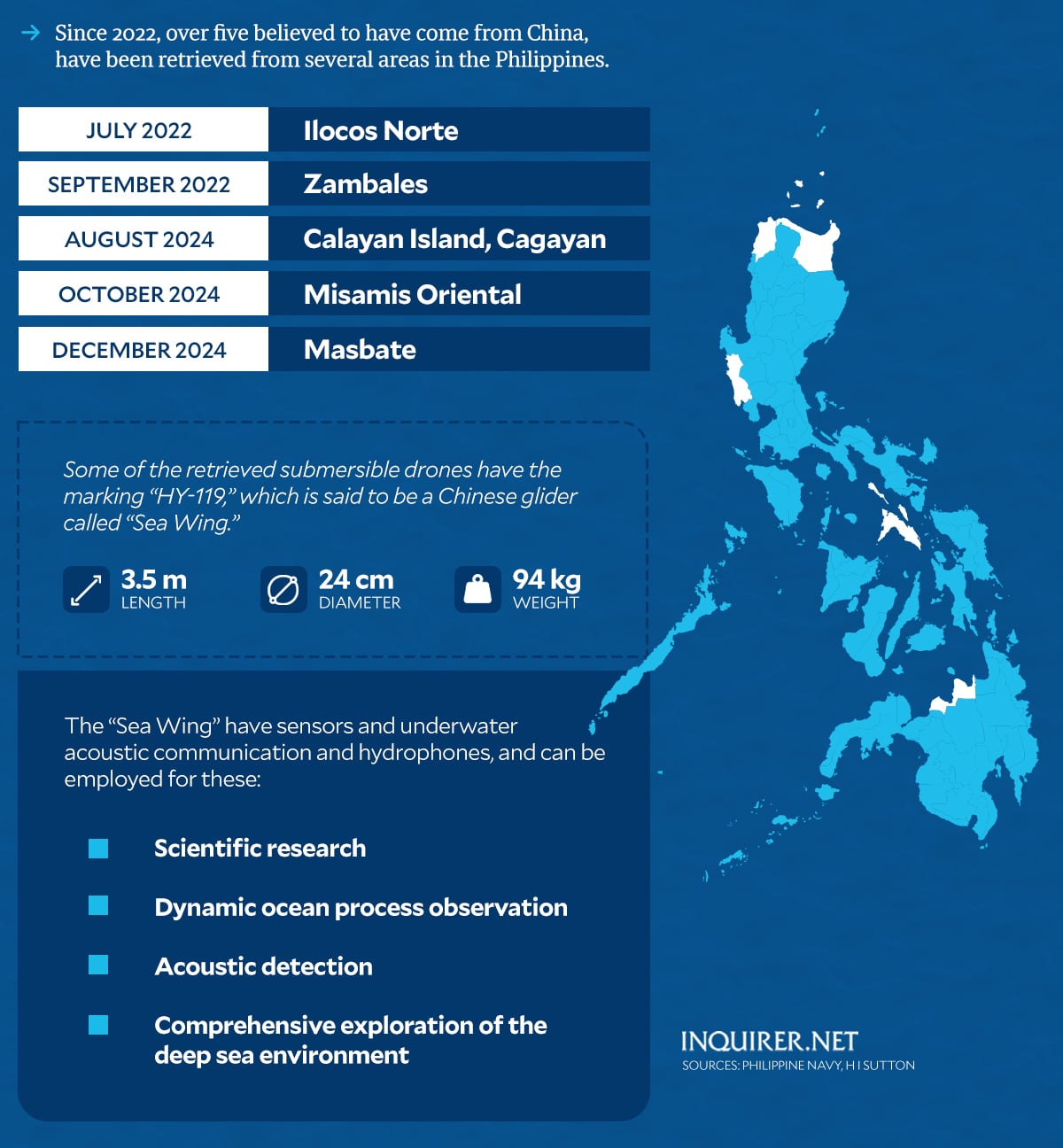
Fast forward to 2022, the Philippine Navy (PN) said two underwater drones were recovered in the waters off Pasuquin, Ilocos Norte in July and off the coast of Zambales in September.
Then in 2024, four more were retrieved – two in Calayan Island, Cagayan in August, one in Initao, Misamis Oriental in October, and one in San Pascual, Masbate in December.
Rear Admiral Roy Vincent Trinidad, spokesperson for the West Philippine Sea, said there is a “50 percent to 80 percent” likelihood that most of the underwater drones were deployed by the Chinese government.
READ: Tests show underwater drones found in PH likely from China
This statement was shared by Jonathan Malaya, spokesperson of the National Security Council, who stated that “the forensic examination [...] allowed us to conclusively determine that they are of Chinese origin.”
As Trinidad pointed out, the drones, retrieved in the last two years, are small, only about “2.5 meters to 3.5 meters in length,” making them “difficult to detect” when submerged.
RELATED STORY: West PH Sea: Philippines recovers suspected Chinese submarine drone
But while the submersible drones are believed to have been deployed by China to map the Philippines underwater terrain, Trinidad said that some obtained key data that could be employed militarily.
“The data received focuses more on bathymetric data, depth of water, salinity, temperature, propagation of sound,” he said, stressing that all of these have applications across different areas.
He said the underwater drones also appeared to have the capability to receive, store, process, and transfer such data through satellite communication to a station on land, a “mother ship,” or other drones.
‘Sea wing’
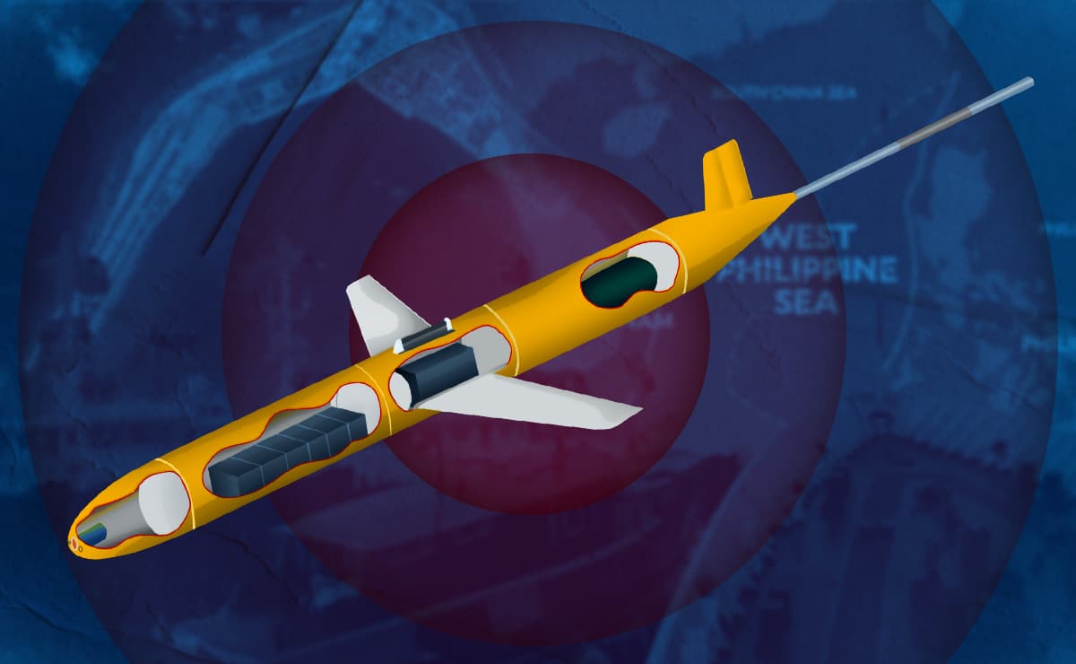
Initially, PN said the last one, retrieved in the waters off Masbate, had the marking HY-119, and as stated in the website Covert Shores by submarine expert H I Sutton, the drone is called “Sea Wing.”
HY-119 have naval and military application, as well as civilian relevance, as they can be employed for scientific research, dynamic process observation, acoustic detection, and comprehensive exploration of the deep sea.

The glider can carry conductivity, temperature and depth sensors, as well as turbulence meter, turbidimeter, chlorophyll sensor, dissolved oxygen sensor, nitrate and other biochemical sensors.
READ: As China flaunts its military might, PH weighs all options
It can also carry acoustic sensors such as “Acoustic Doppler Current Profile,” underwater acoustic communication and hydrophones, said Sutton, who is also an underwater warfare analyst.
As Trinidad said, “any potential adversary who would like to harm our country would need to know the information, not only on land, on air, but more importantly, since we are an archipelago, underwater information”
“It is very clear that these are used for mapping out the underwater terrain, collecting information, like bathymetric data,” he said. “All of these are used across different fields to include underwater warfare.”
RELATED STORY: Zubiri says China may be mapping PH underwater terrain using drone
The areas where the submersible drones were retrieved “are important strategically in the defense and security not only of the country but for international maritime navigation,” Trinidad said.
Last year, Chinese media revealed that researchers have developed submersibles that imitate the “devil fish,” which increases efficiency, resulting in a more effective completion of complex naval missions.
‘Act of espionage’
As Sen. Francis Tolentino said, the retrieval of the submersible drones, as well as the string of alleged “spying” activities, point to a “determined, continuous, and pervasive assault” on Filipinos.
“To be clear, we are facing an unprecedented kind of spying by China,” he said.
But while a clear link between the submersibles and the “Ocean E-Stations” has yet to be established, Felix Chang, a senior fellow at the Foreign Policy Research Institute, stressed China’s capabilities in the South China Sea.
He stated in an analysis published in 2021 that “detecting, identifying, and tracking ships at sea are among the most important intelligence, surveillance, and reconnaissance tasks that any country must perform if it wants to exert control over a maritime area.
“So, it is hardly surprising that China, especially after the early 2010s, has significantly boosted its ISR capabilities in those waters, and none more so than in the South China Sea,” he said.
For Chang, its ISR capabilities have already helped China better assert its illegal claims over the waters within its self-proclaimed nine, now 10-dash line” in the South China Sea.
READ: Suspected Chinese drone ‘non-operational’ when recovered – Navy
“But Beijing has not stopped there. It continues to heavily invest in ever more precise and timelier ISR collection assets in the area, leading one to wonder whether China’s real intention is to develop an ISR network capable of targeting ships far out to sea,” he said.
Chang said the ISR collection assets that China has assembled in the South China Sea “span a wide range of technologies.”
“Each holds certain advantages and disadvantages. If properly woven together into a robust network, they offer Chinese commanders an increasingly accurate and persistent picture of maritime activity in the area,” he said. /tsb
(2025/06/24-14:12)
INQUIRER
- 06/26 05:36 DOJ eyes Japan tech in search for missing cockfighters
- 06/26 05:30 DOJ heeds ICC ‘request’ to assist witnesses
- 06/26 04:30 From mangroves to meals
- 06/26 02:28 BSP: Number of fake banknotes surged by 18.4% in 2024
- 06/26 00:19 DFA launches book promoting PH Studies programs abroad
- 06/25 17:00 Peso strengthens to 56:$1 as Middle East optimism weakens dollar
- 06/25 16:04 West PH Sea: Recent US-PH-Japan sea drills viewed as ‘counter-China’ effort
- 06/25 13:10 Pope Leo XIV appoints Br. Armin Luistro to Vatican dicastery
- 06/25 13:00 PNP-ACG: Most online scammers now are Filipinos who ‘learned’ from Pogos
- 06/25 11:47 Romualdez: House commits to fund thousands of new teaching posts
- 06/25 10:42 Marcos: No need for fuel subsidy talks as prices have not risen
- 06/25 05:55 Duterte rant, partner Avanceña’s rage cited to block his release
- 06/25 05:45 AFP battle staff readies plans amid Middle East tensions
- 06/25 02:09 Faster 5.6% Philippine GDP growth seen in Q2
- 06/25 02:02 BSP wants banks to adopt model risk management
- 06/24 14:12 Chinese submersible drones’ sinister roles in expansionism
- 06/24 13:33 AFP ready to aid gov't in repatriating Filipinos in Iran, Israel
- 06/24 09:19 31 Filipino repatriates from Middle East now safe – DMW
- 06/24 08:29 Padilla seeks Duterte repatriation, but Senate rejects his resolution
- 06/24 02:10 Philippine peso, stocks feel pressure of world on edge
- 06/24 02:08 Middle East war may cut short BSP easing, say analysts
- 06/24 02:03 Offshore wind projects get boost as Philippines launches road map
- 06/24 02:01 Philippines linking rural farms to markets via steel bridges
- 06/23 13:35 More than 100 Filipinos in Israel lost their homes – PH embassy
- 06/23 11:47 Panfilo Lacson says US bombing of Iran nuke sites could start world war
- 06/23 05:50 Over 200 Filipinos in Israel, Iran seeking repatriation
- 06/23 05:20 Carpio: Sara Duterte risks waiving rights without response to court
- 06/23 02:10 Philippine banks cut property exposure to lowest in 6 years
- 06/23 02:08 Property firms endure condo glut
- 06/23 02:07 Likely better harvest lessens rice imports
- 06/22 05:32 Next week’s fuel price hike seen exceeding P5 per liter
- 06/21 18:07 Marcos: ‘We did not yield’ on West Philippine Sea issue
- 06/20 14:42 Sara Duterte may be violating obligation with her trips abroad – Palace
- 06/20 12:51 Marcos meets Japanese tourism partners on 2nd day of Japan trip
- 06/20 11:29 Sara Duterte on personal trip to Australia to join rally for her father
- 06/20 08:58 DOTr studying train line upgrades – Dizon
- 06/20 05:32 UN rapporteur urges PH to return as ICC member
- 06/20 04:00 Philippine conglomerates increase investments in health care
- 06/20 02:20 AGI eyes new luxury hotel, malls through P59-B buildout
- 06/20 02:16 Robinsons Land pumps up REIT arm with 9 more malls
- 06/20 02:10 Preparing Philippine businesses for sustainability compliance
- 06/19 17:59 Torre to police commanders: ‘Don’t hide in your offices’
- 06/19 14:22 New COVID-19 'Nimbus' variant not yet detected in PH, says DOH chief
- 06/19 12:07 Killing of P200 pay hike bill also kills bid for living wage
- 06/19 11:40 7 Filipinos hurt in Iran missile strikes on Israel – PH embassy
- 06/19 11:08 Meralco unit PacificLight switches on 100-MW plant in Singapore
- 06/19 09:56 PH peso sinks back to 57:$1 as US Fed hold boosts dollar
- 06/19 05:12 Barbers pushes for AI-regulating gov’t agency
- 06/19 02:22 DTI launches supply chain, logistics center to support MSMEs
- 06/19 02:18 Firms in Spain earn nod to send meat to the Philippines
- 06/18 16:51 PSEi retreats as Israel-Iran conflict rises
- 06/18 12:25 Motorists will get fuel subsidies due to Mideast tension – Marcos
- 06/18 09:15 Zero dengue deaths by 2030 possible – scientific working group
- 06/18 08:54 Experts urge PH gov't to expedite approval of new dengue vaccine
- 06/18 02:16 Gov’t orders DOE to ensure sufficient oil supply
- 06/18 02:13 Philippines to adopt OECD cryptocurrency tax framework
- 06/18 02:10 New incentives program for electric vehicles seen ‘more inclusive’
- 06/18 02:09 San Miguel leads Philippine firms in ‘Southeast Asia 500’ list
- 06/18 02:04 Philippine exit from list of ‘risky’ markets seen raising investor interest
- 06/17 13:12 MMDA: Driver caught 309 times for same traffic violation in 10 months
- 06/17 12:00 DOTr chief commits privatization of 10 airports by 2028
- 06/17 10:49 House refusal to accept Duterte lawyers’ entry may delay trial – Senate
- 06/17 07:01 Philippines climbs to 51st in global competitiveness report
- 06/17 05:45 Filipina worker wounded in airstrikes vs Israel ‘critical’
- 06/17 02:14 Israel-Iran conflict seen unlikely to derail BSP rate cut
- 06/16 19:07 Senate, House tell agencies: Monitor, help Filipinos caught in war
- 06/16 13:58 Marcos on Filipinos in Israel: Make sure ‘no one is left behind’
- 06/16 11:27 Marcos orders agencies: Prioritize power, internet access in schools
- 06/16 05:40 4 Filipinos in Israel injured amid air strikes
- 06/16 05:36 PH, Japan hold joint drills after RAA
- 06/16 05:32 Problems of past class opening persist in current school year
- 06/16 02:32 Stage set for fresh BSP rate cut to 5.25%
- 06/16 02:26 Final price caps set for clean energy auction
- 06/16 02:20 NEA tasked to help co-ops secure green energy requirements
- 06/15 14:49 DA estimates over 200,000 metric tons of tuna catch in 2024
- 06/13 18:24 AboitizPower P100-B bond program gets SEC approval
- 06/13 17:01 DA lifts ban on beef, poultry products from Germany, Belgium
- 06/13 17:01 DA lifts ban on beef, poultry products from Germany, Belgium
- 06/13 14:55 Edsa 2’s lessons for Sara Duterte trial from Joseph Estrada’s fall
- 06/13 11:55 Sotto: Sen. Miriam taught me that senator-judges can’t make motions
- 06/13 02:30 BSP orders banks to go beyond OTPs
- 06/13 02:24 Filinvest hosts Qatar Airways’ first Philippine office
- 06/13 00:50 Rodrigo Duterte appeals for an interim release from ICC detention
- 06/12 21:56 Marcos offers condolences to India over deadly plane crash
- 06/12 15:34 Chief justice on Independence day: Combat corruption, apathy
- 06/12 14:49 Christian Monsod: Senate decision to remand ‘railroading a wrong power’
- 06/12 13:36 Taiwan’s TPEx tapped to help Philippine SMEs, bond market grow
- 06/12 13:08 Strong, credible voices reverberate vs ‘delay’ in Sara Duterte trial
- 06/12 10:33 Pulong Duterte celebrates independence but dad's detention leaves pain
- 06/12 07:30 Agriculture group urges Marcos to block P200 daily wage hike
- 06/12 06:00 Marcos: Value the nation’s heritage by protecting rights, freedoms
- 06/12 05:44 House, Senate in stalemate over proposed pay hike
- 06/12 05:42 PH removed from EU’s ‘high risk’ dirty money list
- 06/12 02:32 Legislated wage hikes to harm economy, hurt poor Filipinos - economic team
- 06/11 16:29 Solon raises alarm over ASF vaccines for alleged mutation risks
- 06/11 16:24 House to seek clarity on Senate’s remand before receiving case
- 06/11 15:37 No court jurisdiction lost in Sara Duterte impeachment case - Escudero
- 06/11 15:05 Protesters rally in numbers at Senate over Duterte trial delay
- 06/11 13:29 Big business group 'deeply concerned' over stalled Sara Duterte impeachment trial
- 06/11 13:02 Economic team warns of ‘dangerous repercussions’ of P200 wage hike
- 06/11 11:07 Philippines exits EU ‘high-risk’ dirty money list
- 06/11 09:05 Philippine agricultural trade deficit narrows in April
- 06/11 02:28 BSP: FDIs extended slump in March
- 06/10 13:01 41 Chinese vessels seen in various parts of West Philippine Sea in May
- 06/09 14:57 PCG to assess damage caused by grounded Chinese ship off Pag-asa island
- 06/09 12:19 Impeachment process has ‘constitutional infirmities’ – Sara Duterte team
- 06/09 11:36 Senate minority to initiate Sara Duterte impeachment trial this Monday
- 06/09 09:51 F-16 maker sees US making formal offer to PH for fighter jets
- 06/09 05:30 FDA adds 10 more drugs to VAT-free medications
- 06/09 02:09 Philippine market tagged best in SE Asia on slowing inflation
- 06/09 02:07 US agri exports seen growing as Philippines' middle class expands
- 06/09 00:11 South Korea seen to seek deeper security cooperation with PH
- 06/08 02:12 AI is unlocking human potential in new ways
- 06/06 15:23 PH-Japan reciprocal access agreement gets House of Councillors' OK
- 06/06 14:11 ICC prosecutors submit 7th batch of evidence vs Rodrigo Duterte
- 06/06 13:31 Prosecution to present impeachment articles no matter what – Zamora
- 06/06 09:43 Joblessness in the Philippines worsens in April
- 06/06 02:28 Japan debt watcher keeps Philippines' ‘A’ rating
- 06/05 09:16 Inflation cools to 1.3% in May, slowest pace in nearly 6 years
- 06/05 04:36 Reusing plastic ‘a win for everyone’
- 06/05 04:34 Wind power drives Camarines Sur’s energy shift
- 06/05 04:32 In Palawan, a resilient system of seaweed farming
- 06/05 02:28 Philippines may miss growth goal this 2025 – OECD
- 06/04 14:14 Torre pushes for continuing education for police officers
- 06/04 13:25 DA extends issuance of fish import permit till June
- 06/04 12:19 PNP sets 5-minute police response time in a pilot test for Metro Manila
- 06/04 05:55 Senate pressed to fulfill mandate, hold Sara Duterte trial
- 06/04 05:00 DOH seeks emergency declaration on HIV surge
- 06/04 04:55 Marcos lauds upgrades at Naia Terminal 3
- 06/04 02:08 Gov’t debt hit fresh high of P16.75T in April
- 06/04 02:05 BSP enables banks to freeze funds
- 06/04 00:03 DMW to help OFW who had in-flight miscarriage aboard S. Korean plane
- 06/03 16:30 Castro on delayed impeachment trial: Is Senate taking revenge on House?
- 06/03 11:59 Teodoro calls Chinese officer’s proxy war question ‘propaganda’
- 06/03 09:13 HIV cases in PH surge 500%, prompting DOH call for health emergency
- 06/03 05:50 Escudero: Sara Duterte trial delay not tied to Senate power play
- 06/03 05:00 PH, EU to begin dialogue on defense, security issues
- 06/03 02:15 DA okays meat exports from Taiwan, Thailand
- 06/03 02:14 Philippine factory activity cooled in May as US trade war bit
- 06/03 02:10 DTI revisits P1.75-T investment target for 2025
- 06/03 02:09 BSP rate cuts in June and August likely on the table, says Deutsche Bank
- 06/03 02:08 Foreign airlines mull over ‘terminal enhancement’ fee
- 06/02 14:05 Escudero: No Marcos order to delay Sara Duterte impeachment trial
- 06/02 05:42 DOH laments increase in vaping among youth
- 06/02 05:15 AFP: China paper twisting narratives
- 06/02 05:15 South Korea eyes expanded arms deals with PH
- 06/02 05:05 UP study finds method that can detect breast cancer early
- 06/02 02:10 Gov’t raised P390B in borrowings in April
- 06/02 02:09 Poll: Inflation slowed in May
- 06/02 02:04 Razon challenges tycoons’ energy play
- 06/01 23:02 Macalintal: ‘Can impeachment case be carried over to next Congress?’
- 06/01 16:57 Russian vlogger to serve possible 18 months in PH jail – Remulla
- 05/30 13:56 Timor-Leste set conditions before deporting Teves, says Santiago
- 05/30 12:43 China Coast Guard stops shadowing PH civilian ship in West PH Sea
- 05/30 11:52 Teves now at NBI detention facility in New Bilibid Prison
- 05/30 08:00 First Gen calls for price cap review to attract green energy investors
- 05/30 05:44 Surnames of ‘senators’ also crop up in probe of Sara Duterte funds
- 05/30 02:30 Marcos admin drops plan to sell defense bonds
- 05/30 02:22 Filipino firms spending more on cybersecurity
- 05/29 23:41 PH maintains activities in Pag-asa Island, Pag-asa Cays lawful
- 05/29 16:21 Marcos to meet EU executive during visit to PH on June 2
- 05/29 15:42 West Philippine Sea Atin Ito mission: Crewman recalls first sight of Chinese threat
- 05/29 15:35 Philippines plans to improve livestock, poultry import rules
- 05/29 13:54 Teves turned over to PH authorities, departs Timor Leste for Manila
- 05/29 11:23 China assault on Malaysia sovereignty draws parallels to PH ordeal
- 05/29 02:28 Bangko Sentral orders stricter client due diligence
- 05/29 02:16 Philippine insurance sector to outpace global growth


